Friday, August 28, 2015

The Great Canadian Epic, Part 6: In and Around Jasper

So I stepped off the train from Vancouver into the sunshine of Jasper – but the sun was looking pretty weak and sickly.  Since I passed through westbound last Friday, the winds have shifted and started blowing in the smoke from numerous wildfires in southern British Columbia and Washington State.

I’m staying at the Best Western mainly to collect some points.  It’s actually a pretty decent hotel for Jasper, and my room is quite comfortable.  It’s a 2-level loft suite which isn’t nearly as grand or spacious as it sounds, but does have the advantage that the main floor holds a pleasant temperature while the upstairs bedroom area in the loft stays nice and toasty warm, just the way I like it.

The hotel also has a better-than-average restaurant for a hotel in this league, and the chef has come up with some interesting and unusual dishes rather than the usual round of boring standards.  So I had a very enjoyable dinner to unwind after a long day, and a much needed good night’s sleep.

To make the most of your time in Jasper, I recommend having a car.  The main rental companies are all represented here.  There are so many fascinating byways to visit, and the tour companies just don't cover all the possibilities.

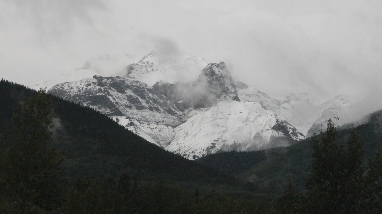
Jasper sits in a mountain valley, with imposing peaks rising on every side.  Although they all appear about the same height, one stands out quite noticeably by virtue of its snowcap and glacier -- which prove that it is actually much higher (mountain country is full of optical illusions like this).  This is Mount Edith Cavell, and the glacier -- known as the "Glacier of the Angel" due to its unique shape -- is one of the sightseeing highlights of the region.  I'm resorting to an internet photo simply because the air wouldn't clear enough for me to get a really good picture of the mountain from close up.  This picture also gives you a good idea of the reason for the glacier's evocative name -- look at its shape. like an angel with outstretched wings.


Here's my own picture of the mountain seen from the main street of Jasper town:


One of the tourist highlights of the Jasper region, ever since the 1960s, has been the Skytram which climbs the mountain called "The Whistlers" just south of town.  One morning, the smoke cleared enough to make it worthwhile to go up, even though many clouds were still about.  Here's a view of the town from the summit:


Here's a view of the Arctic tundra which surrounds you at the top of this (or any) mountain:


And here's a view to the southeast over the Athabasca River valley, with the sun highlighting the light smoke haze that still hung in the air.


I was startled again and again during my visit to the tramway by the fact that every staff member I heard open his/her mouth was Australian.  When did Jasper start to become Australia North?


By the way, the mountain gets its name from the distinctive whistling call of the hoary marmot, a sizable (average 6 kilograms) rodent which lives on this and other mountains.

Westwards from town lies the Yellowhead Pass, of which I have said so much already.  I haven't explained that it was named after a Metis fur trader, Pierre Bostonais, who was active in the region and who thus became perhaps the first memorable blond in Canadian history.  I simply couldn't resist the urge to drive back westwards through the Pass to see Mount Robson again (about 70 minutes west) and so, quite by accident, discovered the tiny gem that is Portal Lake -- right on the Alberta-B.C. border,


And, of course, the inevitable shot of Mt. Robson itself, where I finally got a chance to pose with my towering mountain idol!  (pity the smoke haze hadn't entirely cleared!)


In three days, you just can not cover everything there is to see and do in the Jasper region.  I have been here before, and certainly expect to return.  For today, I chose two of my favourite spots in the area -- favourites because there is a power and music in rushing, falling water that truly speaks to some elemental place deep inside me.  Sorry if that sounds pompous, but that's my reality.  So here are a couple of pictures of Sunwapta Falls, about 50 minutes' drive south of town.


And here's the grandest of all the region's waterfalls: Athabasca Falls, only about 15 minutes out of town. These are glacial rivers, pouring down steep grades and fed by the many tributary streams flowing into each one (with the Sunwapta flowing into the Athabasca) so the power of the water is tremendous indeed, and would be overwhelming during the spring run-off.


There's so much more that I could still say about Jasper. But what draws me back here is the quiet, relaxed tone of this place -- especially as compared to the restless, relentless hustle-bustle which has overwhelmed Banff (to the south). It probably has a lot to do with the fact that you have to drive 5 hours from the nearest major airport to Jasper, as opposed to 75 minutes to Banff. Whatever the reasons, Jasper has a more friendly, down-to-earth feel to it, which I really appreciate. There are no hyper-expensive designer boutiques here, no 5-star celebrity-chef-branded restaurants, and I don't miss them one bit.

The Great Canadian Epic Part 5: Vancouver to Jasper

If you're thinking by now that there isn't much more I could say about train travel, you're right -- almost.

The return trip from Vancouver began with the overnight leg from Vancouver to Jasper.  This 19-hour leg is by far the most popular part of The Canadian's itinerary, and no wonder.  Three whole sleepers were taken up by people getting out at Jasper, and there were only a handful of bags loaded on in Jasper to replace the very large cartful that came off!

The whole feel of the trip was much the same as before, with one exception.  I'm now using a roomette or "bedroom for one" as VIA prefers to call it.  The bed lies lengthwise along the axis of the car, alongside the window, where the bed in a bedroom for two (such as I used going west) lies crosswise, stretching from window to corridor wall.  I found the motion of the train was affecting me very differently and I had trouble sleeping.  After three nights from Jasper to Toronto, I'll have a better idea of which one overall is more comfortable.

The only other major difference is the chance to see the whole route from Kamloops northwards by daylight, so here are a few more pictures of the parts of the Thompson River valley which we passed through in darkness before.  This stretch included a sizable area which had obviously suffered a fire some years back, as we could see the regeneration of the forest already under way.

First, though, a look at the night before the morning after, taken by a fellow passenger at the welcome aboard reception:


Crossing the Thompson River pre-sunrise sky just before our stop at Kamloops:


Travelling north along the Thompson River valley, with the signs of forest fires past all around us and the smoke of forest fires present (much farther to the south) creating a haze in the air:


The smooth waters of the Thompson River showed early reflections at many points along the line:


For the crossing of the Yellowhead Pass, the eastbound trains use the old Canadian Northern Railway track, which takes a longer distance to climb to the same height and thus has a less steep grade.  This track gets high up on the mountain wall even before turning east into the valley which brings the Fraser River down from the Pass.  What should have been spectacular views across the Rocky Mountain Trench from this high-level line were largely veiled, and even Mount Robson -- gloriously in the clear for once -- took on an almost sickly complexion from the smoke in the air:


Wednesday, August 26, 2015

The Great Canadian Epic, Part 4: In and Around Vancouver

So here I am once again in Vancouver, Canada’s great urban gateway to the Pacific.  And, as so often before, I am not actually spending that much time in Vancouver.  I’ve seen most of the urban attractions of the city before, and wanted to get out and explore the countryside round about.  No places I’ve never been before, either, but just that I’d rather be close to trees, water, and mountains than malls, towers, and traffic.

Having said that: if you plan on driving in/around Vancouver plan plenty of extra time.  The road network is continually jamming up due to the natural bottlenecks caused by waterways.  North of the city to the north shore of Burrard Inlet there are only two bridges.  Long lineups are common to both.  South across False Creek: two bridges, same problem.  The bridges across the north arm of the Fraser to the airport and Richmond can get pretty bad too.  And I’m not just talking about weekday rush hours.  Govern yourself accordingly.  The lineup from the north to the Second Narrows Bridge today (Sunday afternoon) stretched back for about 5 kilometres of freeway!

On Sunday I drove north along the shoreline of Howe Sound to Squamish, where I had lunch.  This is one of the most breathtaking roads I know.  It’s called the Sea to Sky Highway and the name is perfect.  One minute you’re racing down a steep slope towards the dark blue waters of Howe Sound and the next minute you’re shooting up a curving hill so steep that there’s nothing solid showing beyond the concrete barrier on the corner!  This is far from being the scariest road I’ve ever driven, but I still don’t want to overdrive it when I’m not used to the road or my rented car.  The locals routinely roar up and down this hillside roller coaster of a road at speeds 20, 30, even 40 kilometres per hour over the posted limits.  Keep right and let them go by!

Most of the route is actually four lanes now, although a few two lane stretches still exist, carved into tiny ledges on the cliff faces.  The entire highway is an incredible feat of engineering skill and dexterity.  Because of the tight quarters there are very few places where pullouts can be constructed for people to enjoy the spectacular views, and some of those are only accessible when southbound.  Whichever direction you travel, getting back on the road after you turn off is a fraught exercise in which stamping pedal to the metal while simultaneously switching on the 4-way flashers is the recommended procedure.

Photography between the marked viewpoints had best be left to a video dashcam.  Only a born bloody fool would try to text or take pix or selfies by hand on the Sea to Sky Highway.  I’m sure some morbid idiots with compulsive death wish syndrome do it. 

For all these reasons, I recommend the more timid or cautious drivers to take a bus tour!

Well, from today’s lazy, hazy summer Sunday here are my pictures taken along this amazing road, starting at Squamish and proceeding southwards.

The view northeast from the town of Squamish to Mt. Garibaldi:


The towering rock face of the Stawamus Chief, looming high above Squamish:


A panoramic view of Squamish, the Stawamus Chief, and Mt. Garibaldi from the next lookout south along the road:


A broad view of Howe Sound and the mountains from the provincial park at Porteau Cove:


This view, also at Porteau Cove, shows the difficulties of the environment the road builders had to contend with -- and without disturbing the railway line which already ran along the base of the cliffs from North Vancouver to Squamish and beyond.


Monday was in fact an in-town day, although much of it was not spent in town.  The morning I passed in the fabulous urban wilderness that is Stanley Park.  I took the time to do something I didn't have time for on my last visit a year ago, and went for a good long walk along the Seawall.  This encircles the entire peninsula that comprises the park, but the stretch I went for was the northwest quadrant, so to speak -- from Third Beach up to the Lions Gate Bridge and back.  Here are a few pictures to show the wild scenic beauty of this stretch of the coast.


As you can see, the Seawall walkway is clearly split into two separate portions: the inner part, raised a little higher, for cyclists and rollerbladers, and the outer half next to the actual wall for pedestrians and joggers.  Even though it was a Monday morning, ample numbers of all these groups were out and about.  It was still a most enjoyable morning exercise.

For lunch I met a friend living in the west end, and after lunch we walked at some length along the continuing pedestrian/cycle path lining the beaches of the city's west end.  And after that I drove down to Steveston, a riverside neighbourhood village which I first seen last year (pictures here: Lotus Land Revisited ), to pay an extended visit to the Georgia Cannery Museum, and to have another nice patio dinner near the river.  

The museum was fascinating, if a little repellent.  Kind of uncomfortable to find out in detail about all the steps that had to go into making a "simple" can of salmon -- and to experience some of the sights, sounds, and smells first-hand!  It was uncomfortable in another way too.  In the early days, most of the cannery workers were Chinese, and they got the dirtiest, most backbreaking manual drudge jobs which nobody else would do.  Just inside the entrance is a machine which was eventually invented to take out a lot of the manual "grunt work" of prepping the salmon.  Its patented name, engraved right into the machine's frame -- no word of a lie -- is "The Iron Chink".  

At any rate, this was a much better than average museum devoted to an industry, and I learned a great deal in the course of my visit.  Dinner on a riverfront patio was at a local restaurant I had not visited before, but it was very good: a delicious grilled chinook salmon fillet (not canned!!) on a stir fry of vegetables and noodles.

Word of warning:  I made a severe error in judgement and used my
video camera to also take still photos on the next day.  Big mistake, the 
pictures are rather grainy.  Apologies for the poor quality of the next few!


For my last day in Vancouver, I decided to take a day trip northwest of the city to the “Sunshine Coast”.  This is a mainland region, but can only be reached by ferry since there are no roads linking the area to the outside world.  This map helps to show why – especially when you realize that all the land areas shown are mountains rising straight up out of the ocean!


 The crossing of Howe Sound gives you a spectacular opportunity to photograph this incredibly beautiful fjord from its southern end opening into the Gulf of Georgia.  The crossing takes 35 minutes.  Since the ferry is the only way in or out of the Sunshine Coast for a vehicle, you are charged the full round-trip fare on the inbound route from either south or north. 


The ferry arrives at Langdale, which is just a ferry terminal and nothing more to speak of.  But it takes only a few minutes to drive south from Langdale to Gibsons, which was the filming location of the 1970s CBC TV series The Beachcombers.  This show has achieved cult status in many parts of the world, and people come from all over the map to see the buildings and places associated with the show.  The central character’s boat, Persephone, is preserved in a parkette on the main street.  Gibsons is a pretty little place with a few interesting shops, galleries, restaurants and pubs – as well as multiple marinas and amazing views over Howe Sound.


Gibsons also features some rather quirky treatments of streetside hydro junction boxes.


I then drove a few miles west and north to Sechelt, on the inner end of Sechelt Inlet, another fjord.  There I had a waterside patio lunch of a halibut sandwich and salad, while contemplating the fact that you could walk overland here from the Gulf of Georgia to the end of Sechelt Inlet in half an hour or less, while it would probably take you a pretty full day to sail around on the water (see map above).

After lunch, I drove back to the beach on the Gulf side and walked for a few minutes, then returned to Gibsons for a coffee on a café patio.  From there, it was back to Langdale and the return ferry ride.  Back on the mainland I detoured for the first time ever up the Cypress Bowl Road, and came to the viewpoint which has the best mountaintop view of Vancouver I’ve ever seen.  In spite of the smog the view stretches for miles into the distance, and the closer-in parts are much clearer than they can be in summer.  It was a fitting crown and “highlight" to my three days of Vancouver adventures. 


 By 6:30 pm I was back at the station, waiting to board the train for the first leg of my return trip, from Vancouver to Jasper.

Saturday, August 22, 2015

The Great Canadian Epic, Part 3: Prairies and Mountains

Aaah, the wide open spaces of the Canadian prairies.  Everywhere you look from the train, you see the appurtenances of farming: the broad fields, the lines of trees serving as windbreaks, the steel sheds housing farm equipment, the irrigation hoses and sprinklers, the huge grain elevators.  The landscape is a patchwork of green, yellow, beige, and brown, depending on which crops are being grown (or not) in each big square field.  

There’s a popular impression among many people that the prairies are as flat as a billiard table.  As the old saying goes, if you stood on a gopher hill you could see all the way to China.  This is not true.  The area around Winnipeg and westward as far as Portage la Prairie conforms to that stereotype, but generally the land shapes itself into long rolling slopes which gradually climb up to meet the sky somewhere off in the middle distance.  The vast surface of the prairie is also carved by the valleys of rivers and streams, and speckled with salty ponds and pools known as sloughs. 


Take the region as a whole from east to west, and it actually consists of a series of three broad steps rising towards the foothills of the Rocky Mountains. 

It takes a bit of time to get used to Prairie towns and cities too.  Given the vast amount of open space available, towns were laid out on a wide scale with broad streets and with the railway station always near the centre of town.  A central feature of every old prairie town was the classic grain elevator, next to the railway tracks, and a few of the old traditional style elevators can still be seen.


 So, as we rolled west away from Winnipeg the track was dead straight and dead level and we moved right along at a good fast clip.  The line passed just north of Brandon and then the country began getting hillier, until we were actually climbing a distinct grade that slowed the train down noticeably.  The hills rose around us, looking reminiscent of Scotland with plenty of trees and grass added.  At the same time we collected a hearty little rain shower lasting perhaps 20 minutes (hence the splotches on the window). 


Across that height of land we dropped back down for a while, but then began climbing again until we were running high up on the north side of the Assiniboine River valley with its distinctively flat skyline at the top.   As soon as we levelled out at the summit we were back on more-or-less level prairie again.  And that was the first of the big steps (the second one passed during the night).

The following morning I was up very early (the time changes were getting me farther and farther ahead of normal clock time) and into the dome car where a welcome early cup of coffee woke me up enough to get some lovely photos of the prairie sunrise. 


The Skyline activity and dome cars have 24-hour coffee and tea on tap, with fruit and light snacks such as cookies.  No hurry, because the train was an hour and a half late getting into Edmonton.  These things happen, and any passenger on The Canadian needs to feel ready to roll with it.  At Edmonton, the train has to back into the station on its dead-end track.  Here, the Panorama full-length dome car has to be added.


Meanwhile, baggage has to be taken off and more baggage loaded in.  Then passengers have to be boarded or reboarded.  It’s a wonder that the crew managed all that in just under an hour (it’s scheduled to take an hour and a quarter).

Unlike, say, the Front Ranges of Colorado, the transition from prairie to mountains on this route is more subtle and takes longer.  It passes over the space of several hours while the dining car serves a leisurely brunch with open seating between 9:30 a.m. and 12:00 noon.  Hills gradually rise around the track, which is mainly through forest, and there follows a notable climb up to Obed Summit, west of the Saskatchewan River valley.  The train then drops down to cross the Athabasca River, and follows its broad mountain valley all the way to Jasper.  


As you would expect, the views are spectacular on both sides of the train, and the dome cars rapidly fill up – even on a day with clouds and rain like today.  But there were still seats in the domes for all who came.

Arrival in Jasper is in early afternoon.  People tend to think of Jasper as a resort, but its first and primary reason for existence is as a service centre for CN.  VIA Rail has a sizable presence here as well, with both the Canadian and the thrice-weekly Jasper-Prince Rupert train using the station.  It’s a beautiful old historic station building, right on the main street, and during the extended stopover here there’s time to get out and explore some of the shops and cafes which take up the street facing the station, and the street behind it.  Also Jasper is a very good place to shop for any important item you may have forgotten. 

I certainly took good advantage of the clear but cool walking weather, as the sun had begun to peep from between the clouds.  The first snow of the coming winter gleamed on the surrounding mountains, and the air certainly had an autumn-like feel to it.  But this can happen at any time of the year in a mountain resort town well over a thousand metres above sea level.  I’ll be stopping here for three days on the return trip, and will give a more detailed rundown on Jasper at that time.


Because the Yellowhead Pass is at such a low altitude, there is almost no climbing at all out of Jasper before reaching the summit of the pass, only a short distance west.  There then follows a long descent past the expanse of Yellowhead Lake and Moose Lake.


From there the train runs down the long grade above the rapids of the newborn Fraser River, a lusty and energetic baby if ever there was one. 


Not long after that, Mount Robson, the tallest peak in the Canadian Rocky Mountains, looms into view on the right and to the rear.  Those of us seated at the back of the Skyline dome were perfectly placed for pictures, not least as we continued down the track, with the mountain sitting dead-centre behind the train.  Mount Robson's huge bulk is more than capable of generating its own weather.  I saw it full and clear in 2007 (see that picture here: Into the Mists: Canada's Pacific Northwest ) but I now think it looks even better with some weather in place.  It brings to mind that oh-so-evocative phrase from Shakespeare’s The Tempest:  “…the cloud-capped towers….”


Soon after that the train turns south into the Rocky Mountain Trench, and crosses that broad valley to climb over the Monashee Mountains and descend into the valley of the Thompson River.  This upper stretch of the Thompson valley is heavily forested.  Among the forest trees appears another scenic spectacle, Pyramid Falls (so called because of the shape of the waterfall).


This appears on the left during the evening and not long afterwards night descends.  Sadly, then, you miss the spectacular seared-desert scenery of the lower Thompson Canyon, and the steep mountain walls of the Fraser Canyon. 

Several of us lingered late in the dome, not anxious to leave.  You quickly form a special kind of partnership with your fellow passengers on a trip of this kind.  Part of this is because of the strongly international flavour of the train's population.  Within a small group of no more than 150 people (who shared my dining car and Skyline dome car), I met residents of several parts of Canada, a number of U.S. states (including New York, Maryland, Tennessee and Texas among others), Britain, Germany, Denmark, Australia, Japan, China -- and I'm sure I've forgotten a few.  As one of the group, Sarah (from Australia), observed on the last day, our varied stories were an important part of the total experience we all shared.

We dedicated dome sitters were of course a smaller, closer group.  Our little fellowship was certainly fostered by Hollie, the attendant in charge of the Skyline activity/lounge/scenic dome car during the second half of the trip.  With her flamboyant sense of humour, her great knowledge of the route, her willingness to answer and ask questions, and above all her energetic hospitality, she made the Skyline into a delightful place that rang with laughter and made people want to hang out there, and help each other get the best pictures they could. 

If you (like me) are an early riser, you make it back to the dome car by 5:45 a.m. with an early cup of coffee while the train is stopped at Hope and get some more pictures of mountain scenery and a final gorgeous sunrise before going for the last breakfast of the trip.  In fact, several of us were in the dome before 6:00 a.m. and witnessed the unforgettable sight of a sunrise over the mountains.


The train, ahead of time at last, rolled into Pacific Central Station at 9:00 a.m., forty minutes early. It says a lot for the special quality of the experience that people lingered, still chatting, in the station, reluctant to break the bonds we’d formed until it was time to pick up our bags and go our separate ways. 

Coming up in the next post, some scenery and other delights of Vancouver.