Thursday, March 14, 2024

Sunshine Supertrip # 3: A Real Desert Island?

Strictly speaking, Aruba isn't a desert island, although it may appear close to that at a casual glance. Early Spanish explorers labelled it as a "useless" island, but that certainly doesn't tell the whole story either. 
 
Although Aruba and Curaçao are very near neighbours, and share a similar mix of nationalities and cultures, there are some significant differences between them -- as I discovered during our one-day stop in Aruba. I admit that I may be selling Aruba short due to limited experience, but during my visit I saw no sign of the playfulness which kept bubbling to the surface in Curaçao. Aruba seemed, by contrast, to be business, through and through.

I first sensed that when I came off the ship. We were on a utilitarian concrete dock, a fair distance from the centre of Oranjestad, the capital. The dock gave every appearance of being easily adaptable to cargo service, and it probably is. You have to go some distance outside the dock area to hit the first shop. In Curaçao, the shopping district begins inside the security perimeter of the cruise terminal! Here's the view of the dock area and the city from the ship's decks.


The tour which I took didn't go into Oranjestad, but as far as I could see from my ship's upper decks, Oranjestad had only one or two examples of the colourful old architecture which so characterizes the centre of Willemstad in Curaçao. Instead, Oranjestad has ample examples of modern glass-and-concrete business architecture.
 
As we were leaving the port and driving northwest along the shore road, our guide pointed out, at great length and in detail, each of the many resorts along this beach stretch. I understand that tourism is the mainstay of Aruba's economy, especially since the oil refinery has been mothballed, but our guide's endless emphasis on it certainly reinforced my impression that Aruba is all about business! It's not hard to see that these resorts would have to use a lot of desalinated water in irrigating their beautiful lawns and lovely gardens.


Since my tour in Curaçao focused on cultural features, it seemed appropriate to pick a tour directed at the nature lover here in Aruba. So I did that, and here's what I found.This island isn't nearly as large as its near neighbour, but within that small area there are significantly different natural regions. The southwest side, in and around Oranjestad, is largely flat and, in landscape terms, monotonous. 
 
The northeast side, which we visited during our tour, is rugged and hilly, although not rising to very high altitudes. The hilly region is formed of volcanic deposits of great age, but there is no other or more recent sign of volcanic activity here. Much of the remainder of the island is formed primarily out of limestone, a pale grey colour, covered with broad stretches of light brown sand. If the rocks were red sandstone instead, the whole place would begin to look like it belonged in the American desert southwest.
 
 
While the Hooiberg looks like a perfect volcano shape, it's not volcanic. It's a noticeable and prominent feature in the middle of Aruba's flat region, but that's all. There is a trail climbing to the top of the Hooiberg which has 587 steps, according to one account I read on line. I didn't propose to check that particular detail myself.
 
 
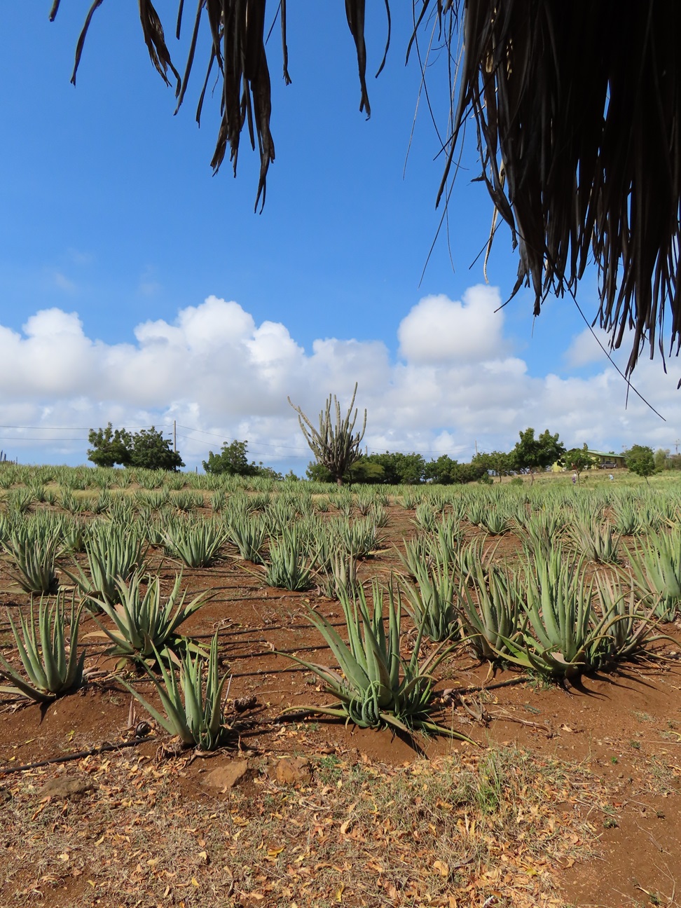
Aruba will appear to most visitors as being, for practical purposes, nearly a desert, even though its climate is officially defined as semi-arid. Large clusters of cacti and scrubby bushes dot the landscape, and tree growth is limited to barely three percent of the island's land area. On average, Aruba receives only 16-18 inches (406-457 mm) of rain annually -- and it shows. The aridity is believed to have been caused largely by deforestation during the Spanish era of the colonial period. The aloe vera is another plant which makes itself right at home here, its economic significance attested by the choice of the plant to appear in stylized form on the Aruban coat of arms.


Our first of three stops was at a butterfly farm. Here we got a detailed explanation of the complex biological mechanisms which dictate the life cycles of butterflies and moths. During his talk, our guide was able to find caterpillars hiding under leaves, and spot a female butterfly in the process of laying one of her eggs. He even spotted a pair of butterflies mating. With so many butterflies whizzing around inside the large netted enclosure, it seemed pretty difficult to take a picture that didn't have butterflies. The challenge was to find one where the butterflies would sit still long enough to pose. The brilliant blue ones were especially difficult to capture sitting still. But I did my best.


This is a rack of pupae or cocoons, some of them in the process of breaking open to release the adult butterflies. The butterfly will have to sit and allow its wings to unfold and dry for 24 hours before trying to fly on them. That glorious specimen in the middle was the only one of its kind which I saw.


From here we drove on to Casibari Park, a site of sizable and startling natural rock formations. Like many amateur travel writers, I've been known to crack jokes about the Amazing Scenic Boulder Tour. This place was of another order, though. I had trouble guessing whether the rocks had been thrown together here by force of nature, or if they were eroded into these fantastic shapes where they sat.  I didn't climb the stairs of the main hill as the rocky steps were uneven and there were no handrails except at the top. But there were plenty of intriguing formations to be seen down at ground level, in the area around the highest rocks.


Casibari was also the place where I tried to make friends with this little Aruba whiptail. It's an endemic species. This one was, at a rough guess, about 100 mm long (4 inches).


We then drove northeastwards, up into the hill country and over to the northeastern shore. Here we were just at the edge of Arikok National Park, which encompasses most of the Aruban lava beds. 
 
 
This is a shore where the ocean, driven by the northeasterly trade winds, is busily engaged in carving and remaking the landscape. Here we saw the Natural Bridge.


You might wonder how that convenient open space on the landward side of the bridge came to be. Here's a photo of a new one, just beginning to form. It's usually a matter of the water eating its way in through crack and crevices in the rocks, and then eroding the sides of the openings until the land above collapses into the vacant space underneath.


Our guide told us that this was the "little" bridge. The bigger one collapsed one night in 2005. Even this one, he told us, has gotten noticeably longer since then as the ocean keeps gnawing away at the foundations at sea level. As with ocean-carved natural bridges everywhere, it's only a matter of time.

This coastal lookout point is also a great place to watch and try to catch the "big one" smashing into the rocks. This is a place where you really need video to depict the violence of the cross-currents as the waves pile into the shore from different directions, no doubt redirected and distorted by crumbled rocks hidden below the surface.


Despite the reddish appearance of the rocks, due to the sand overlay, these are actually beds of the same limestone variants which form so much of the island. 
 
For a single morning outing, this tour gave a quick cross-section view of several different landscapes in Aruba. This island is a very interesting place in its own right, and certainly not typical of what most people imagine a Caribbean island as being.


Wednesday, March 13, 2024

Sunshine Supertrip # 2: Dutch Orange Sunshine

The main destinations on this cruise are two of the six Dutch Caribbean islands. Perhaps the most famous single sight in all of these islands is the Queen Emma pontoon bridge crossing over to the colourful row of Dutch-inspired buildings along the Handelskade in Willemstad, the capital of Curaçao.
 

Aruba and Curaçao each rank as Constituent Countries in the Kingdom of the Netherlands, alongside Sint Maarten and the Netherlands itself. The three less populous islands, Bonaire, Sint Eustatius, and Saba, have the status of Special Municipalities.

On a more casual level, the six islands have often and traditionally been referred to as the "ABC Islands" and the "SSS Islands." This map shows clearly why. The ABC Islands lie well to the south, just off the coast of Venezuela in South America in fact. The SSS Islands are much farther northeast, in a very crowded neighbourhood which includes islands formerly (or still) ruled by Britain, France, Denmark, and the United States as well as the Netherlands. Indeed, Sint Maarten is famous for amicably sharing its island home with the French overseas collectivity of St. Martin. The  map doesn't show the two smallest islands, Sint Eustatius and Saba, but they lie more or less south of Sint Maarten, and west-northwest of the French island of Guadeloupe.

Base Map Attribution: https://freevectormaps.com/world-maps/caribbean/WRLD-CI-02-0001?ref=atr

To reach Curaçao and Aruba, our ship had to follow a slightly snaky course. It was inevitable that the large islands of Cuba and Hispaniola (Haiti/Dominican Republic) would get in the way.

Base Map Attribution: https://freevectormaps.com/world-maps/caribbean/WRLD-CI-02-0001?ref=atr
 
We've come directly down to Curaçao from Fort Lauderdale, a stretch which takes two full days at sea. Those multiple sea days are the special attraction of this cruise for many of those on board. As well, there is the two-day stop in Curaçao. This is a feature that is becoming more common on cruises in recent years, at locations where there are many attractions ashore which people might wish to explore. We are docked there from Monday at noon to Tuesday at 11:00 PM. We then spend a day in Aruba, before beginning the return voyage, with two days to the stop at Half Moon Cay, and one last overnight back to Florida. 
 
Curaçao has one of the most diverse populations you will find anywhere on the planet, outside of the major international trading cities. There are over 100 nations represented in the population here, and over seventy separate and distinct religions. In such a society, it's scarcely surprising that the common local language is a polyglot mixture of indigenous Caribbean speech, several African languages, and Portuguese, all stirred together into a glorious melting pot of intersecting meanings called "Papiamentu."
 
As our guide explained to us, the school system teaches in addition two languages which every student can speak fluently at graduation: English and Dutch. Many also speak Spanish and/or French. 

Curaçao and Aruba are both dry, semi-arid islands. Tropical in latitude, they feature the common two seasons of tropical climates all over the world: Wet and Dry. Even in the wet season, though, rain seldom happens except at night. In looking at this decidedly dry environment, bear in mind that my visit took place during the Wet season. The yellowish tone of many of these pictures comes from being taken through the window of a moving tour coach.


Curaçao's capital of Willemstad is distinctly a two-part city, as the photo at the head of the post shows. It is split down the middle by the narrow channel of Sint Annabaai, a natural waterway connecting the open ocean to the inner harbour, the Schottegat. This picture shows a small oil tanker entering Sint Annabaai, enroute to the oil refinery on the far shore of the Schottegat. Needless to say, since the ship was moving steadily into the channel, Queen Emma had already moved out of the way.
 

She's attached to the shore at one end, and pivots around that end like a hinge of a door. The photo at the heading of the post shows Queen Emma moments after she had closed again following the tanker's passage -- which explains the huge, dense mobs of pedestrians crossing the bridge in both directions. There are passenger ferries to maintain crossings of Sint Annabaai when the bridge is open, but I suspect most people find it easier to just stand and wait. Queen Emma's propensity for opening and shutting has led to her other, and much less official, name: "The Swinging Old Lady." In this shot, you see a nearby pub named after the bridge.
 
 
The bridge was originally installed in 1888 and rebuilt in 1939. It was named after the Queen Consort of the Netherlands in 1888, Queen Emma. It's now used solely by pedestrians. Here are some views of the two shores, taken from the middle of the bridge. On the east side are the colourful buildings of the Handelskade (Workers' Quay).


On the west side, you get the more open space of the Brionsplein (Brion Square).


In between them, crossing the inner end of Sint Annabaai, is the much newer Queen Juliana bridge, opened in 1974, which completed a four-lane road link around the Schottegat and permanently solved the traffic problems created by the Swinging Old Lady.


And here, on the Handelskade side, is the clever solution to the perennial problem of romantic people wanting to fasten lovelocks onto bridges. It's supposed to be a touching symbol of True Love Forever, but I have always looked on these things with an ironic eye after learning that people sometimes end up with three or four (or more) locks on the same bridge.
 
 
The Handelskade is the tourist highlight of the east side of town, the Punda ("the Point"). The other side is laconically called Otrabanda ("the Other Side," in case you hadn't guessed already). The cruise terminal is located in Otrabanda. 
 
Here are a couple of pictures taken from, the high level road crossing, the Queen Juliana Bridge. The first shows the view of the oil refinery and the Schottegat.


The other direction shows the two-part layout of old Willemstad, the venerable Queen Emma bridge, and the cruise ship port with our ship.


Here's a map of the city to give you an impression of the whole layout.

Source map: Open Map Project
 
On the short walk from the cruise terminal to the centre of town, you pass a restaurant called 5 O'Clock Somewhere Curaçao, and this is a recurring theme in gift shops with tee shirts, postcards, wall signs, shot glasses, you name it. You also pass in front of the Renaissance Resort. What you don't see from the walkway, behind the building across the road, is the resort's enormous outdoor pool with artificial beach, sandy bottom, and infinity wall -- all located inside the wall of the Old Rif Fort (and seen here from the top deck of the ship).


The resort incorporates the Old Fort on the tip of the land beside the entrance to Sint Annabaai. It's not just the pool. The main courtyard of the fort has been converted into a shopping mall with multiple restaurants, plainly aimed at the tourist and cruise trade, and the walkway from the cruise terminal to the centre of town passes right through the fort. The corresponding fort in the Punda, across the channel, has also been incorporated into a hotel.
 
 
Our morning coach tour took us around some of the districts in the city before heading out to the countryside. As soon as you look at this waterway in the Punda, the Dutch influence is obvious. 
 
 
The brilliant colours of the buildings are said to be the result of a decree by a long-ago Dutch governor that white and whitewashed buildings were forbidden, since the brilliant whites exacerbated his migraines. Years later, after he had passed away, it was found that he had been the owner of the biggest firm of paint merchants on the island. Whether that's all true or not, the colours are certainly lively, and the owners take good care of the brilliantly-painted limestone from which so many of the buildings are constructed.


Even these small cottages originally built for labourers share the colourful look.

 
Some are covered with attractive murals instead of plain vivid colours. 


Once you leave the central area, the outlying districts around Willemstad incorporate much more modern and architecturally less interesting buildings. It's here that you find yourself in the commercial district, surrounded by groceries, hardware stores, and light industries, and full of chain restaurants such as McDonald's, KFC, Burger King, and Pizza Hut. I'm glad the tour bus didn't bother stopping!
 
Our tour had three main stops. The first was at the Landhuis Chobolobo, which now houses a distillery producing the "the original Curaçao liqueur." 
 

Here, as the guide explained to us, the bottles which hold the world-famous spirit are dictated by law. They must be orange-shaped, as shown here, and the glass must be textured like the peel of an orange.


The liqueur has just four main basic ingredients: cardamom, cane sugar, dried peel from Valencia oranges, and cloves. In the photo above, the row of five bottles all hold variants of the standard and traditional orange flavour. The second row of four supplement the orange with other flavours including chocolate and tamarind. We were offered tastes of three: the chocolate, the tamarind, and the orange triple sec. It's funny how many of these cruise tours seem to involve day drinking, especially as in this case when it was still only 9:15 in the morning.
 
Sure enough, there's another sign to reinforce that recurring theme.
 
 
Our next stop was farther out in the rural countryside at a plantation growing aloe vera. I've never heard anyone say it like this before, but here in Curaçao it's pronounced "a-lo-ee vera." We were given a fascinating illustrated talk about the growing habits of the plants.


The talk also covered the goats grazing among the rows of aloe vera, shown here in a photo from the coach window as we arrived. Apparently their natural fertilizer is very agreeable to the aloe vera plants.
 
 
Our final stop was at Serena's Art Factory, a workshop for making traditional Chichi sculptures. We learned that "Chichi" was a title given to the oldest daughter in the family, and that younger siblings would not call their oldest sister by name but address her as "Chichi." A similar title of respect for the oldest son was "Bubu." 

The sculptures are formed in a mold, and then brilliantly coloured with many patterns and designs, traditional or otherwise, according to the ideas of the various artists who paint them by hand. The facility also offers painting workshops to visitors. The small artist-painted pieces in the shop are sold under the trademarked name "The Real Chichi" as a guarantee of local and hand-made authenticity. The large-sized pieces on display in the gardens are nothing if not eye-catching.


Easy to overlook amid all these bright colours was this more subtly toned turtle, enjoying a mid-morning snack. 


For a whole range of reasons, I could certainly consider returning to Curaçao as a vacation destination in its own right -- and I know there are many more aspects of the island which I haven't yet seen. But now: on to Aruba!