Sunday, January 31, 2016

Sightseeing the Gulf Coast Part 3

Just over a year ago, when I was on holiday in Florida, I wrote and published two posts about touring the Gulf of Mexico coast from Clearwater Beach (near Tampa) as far south as Sarasota.  Here are the links to those two posts, if you'd like to revisit them.


At the end of the second one, I promised shortly a Part 3 about the area from Sarasota down to Fort Myers.  And then procrastination set in, accompanied by a strong dose of other trips.

I'm back in Florida again, and although I didn't really expect to put up any posts this year, I changed my mind.  Actually I made a snap decision to change plans and head for Fort Myers when the weather in Clearwater stayed obstinately cool.

Before I get to that, though, I want to show you what can happen when major storms hit this coast.  Almost all of Florida is very low and flat, and when land is reclaimed for development you end up with houses and apartments built on controlled sandbanks.  However, there are a few nature sanctuaries which show us what all of the coast was like before the tourism boom struck.  Last year, I visited Fort de Soto park southwest of St. Petersburg.  I shared a couple of these pictures before, but here they are in comparison with this year's versions.  Quite plainly, Fort de Soto has had at least one dandy storm, maybe more than one, and a good deal of the North Beach has migrated inland.

The first one shows a tidal lagoon, one of several in the park, at mid tide.


Now, the same location after the bad weather.  The lagoon is filled in with sand, cut off from the sea, and almost dry except for a couple of rain water puddles.  And this was at high tide!


Before the storms, the beach was lined with a dense growth of trees and shrubs.


Now, much of the growth has been killed, uprooted, or snapped off and the sand has pushed all over the ground growth that was there before.  Beyond the trees, you can see what looks like a wooden patio railing.  That was a footbridge across the narrow inner end of the tidal lagoon.  It's now resting on a solid sandbank, buried right up to the level of the walkway.


All the area beyond the dead trees was a grassy picnic ground.  A good-sized area of it is now covered in sand.


This can happen because the sand, which looks so much like snow, also acts in the same way.  All along this coast, the sand is a very light, fine powder.  It picks up and moves in the wind, drifting like snow.  When hit with high water, such as storm surges, the sand easily suspends in the water and can be moved great distances before the wind drops again.

The other major change at Fort de Soto?  In my previous post I proudly advertised that the park was free for day use, apart from the 50-cent toll on the access bridge.  Tempora mutantur.  Fort de Soto Park has now been taken over by Pinellas County and there is a $5.00 daily fee per vehicle, collected at the entrance station.  Pity.  But even at $5.50, it's well worth anyone's time and money as a place to visit, walk, bike, picnic, swim, or just laze in the sun on one of Florida's most beautiful beaches.

Well, with that out of the way, what is there to see as you travel south from Sarasota?  The area from here to Fort Myers is far less heavily developed than other regions of the Gulf Coast.  There are the usual shopping malls, condos and neighbourhoods arranged around canals, but far less of them than in better known regions.  The towns as a result are much smaller.  

The historic district of Venice is an interesting place to walk and shop, and with many interesting places to eat as well.  It's a bit of a detour off the main Interstate, but well worth while.  Farther inland is the sizable expanse of Myakka River State Park, while the Myakka River State Forest sits by the mouth of the river on the Gulf side, offering riverfront camping sites.

Interstate 75 actually crosses two major rivers along this stretch.  Both are very wide waterways.  First is the Peace River, between Port Charlotte and Punta Gorda.  Then comes the Caloosahatchee River (say that three times quickly!) on whose banks downtown Fort Myers stands.  Fort Myers brings us back to the world of major Florida development with a bang.  It's another huge, sprawling collection of endless suburbs with endless shopping malls, gas stations, and fast-food joints, all knit together by a network of major arterial roads -- most of them with a 45 m.p.h. speed limit.

The road that matters the most is Summerlin Road.  Find that one, and you've found the way to the beaches.  Fort Myers Beach is reached by turning south on San Carlos Boulevard from Summerlin.  It's crowded, noisy, boisterous, traffic-ridden, and busy as hell.  

Get there early in the day and you may find a place to park where you don't have to pay.  Maybe.  You might even find enough space on the beach to spread out your towel, especially on warm weekends!  Right at the bottom of the bridge connecting the beach island to the mainland is a poorly planned street intersection which is guaranteed to create traffic jams all day long, in every direction.  If you plan to just stay at Fort Myers Beach for a week, and never take your car out at all, then one round trip through that morass of traffic might be considered an acceptable penalty.


However, if you skip that turn and stay on Summerlin all the way to the end of the road, you'll come to a toll station.  For $6.00 you can cross the causeway to Sanibel Island, and enter a different world altogether.  Sanibel has managed the near-miraculous feat of maintaining a very natural appearance in spite of development.  The main highway running the length of the island is thickly lined with trees and shrubs.  Houses as often as not are concealed behind greenery.  Small shopping centres and their parking lots alike are shaded by large overhanging old trees.  Even along the south shore beaches, no apartment, condo or hotel stands any higher than three stories.  All are set behind a strip of natural greenery designed to protect the beach.


The beach itself is world-famous for shell collecting.  Instead of the fine powdery sand of farther north, the beaches here seem to be composed entirely of the crumbled remains of shells.  Large and small pieces abound.  The collectors are everywhere, avidly searching for whole shells with beautiful colours.  The bending posture of the shell collector is so characteristic that it even has a nickname: "the Sanibel Stoop."  This year I was just on a day visit, but when I stayed on Sanibel 2 years ago, the hotel actually had a special sink beside the path coming in from the beach for washing off shells!


The big black one by the toe of my shoe is called a pen shell.  They're all over the place, usually broken -- the shell doesn't seem very thick in relation to its size.  If the sun catches them at the right angles the shell can give off a bronzey glint.  The interior of some pen shells is lined with mother of pearl and occasionally they can grow pearls.


Sanibel and its even quieter attached neighbour, Captiva Island, between them post a collection of pretty fabulous restaurants.  Many of the best, as in other resort areas, are housed in old wooden buildings of quaint Florida character.  One of my favourites, the Island Cow, is decorated with dozens of ceramic and plastic cows (and other critters) of every shape and size on ledges around the upper walls.  Apologies that the picture is a tad blurry.  My phone doesn't much like working indoors.


For me, the real highlight of Sanibel is the J. N. "Ding" Darling National Wildlife Refuge.  It takes up much of the northern half of the island, a preserved slice of the Florida coast before the arrival of the invasion of real estate developers and agents.

Because it is largely made up of a mangrove swamp, alternating with stretches of open water, the Refuge is hugely popular with sea birds.  There is a scenic drive through the reserve, all paved, with a $5.00 admission charge ($1.00 for cyclists or walkers).  In busy seasons, there are also tour trams that run through the refuge for those who want to concentrate on the views.  Not the least of the attractions is the quietness of the place.  Along the way, there are numerous spots with good views of the waterways, and there are always at least some birds to be seen.  The first pictures are from two years ago, and show a pretty typical view of the Refuge.  These egrets were standing barely twenty feet from the road and seemed utterly unperturbed by the horde of camera-swinging wildlife spotters and cars.


This picture, taken from a boardwalk, gives a great view of the water-and-mud-dwelling mangroves which have literally given so much of Florida its shape.


This sandbar in a lagoon is a popular haunt of several species -- including a couple perched in the trees.


Now for this year.  For whatever reason or reasons, the Refuge was really popular this week with the birds.  Here's the same sandbar, as seen yesterday.


In a tree shrouded bayou, dozens and dozens of egrets were on a fishing expedition, all squawking like mad.


This fine specimen obligingly posed for my phone's camera.


While these two managed to get themselves caught on the fly, so to speak.


I spent almost two hours there before realizing that I was getting hungry and perhaps ought to be considering my own lunch.

I keep meaning to visit other points of interest around the Fort Myers area, but somehow I always end up back on Sanibel and Captiva Islands, and especially at the Ding Darling Refuge.  After these pictures, I hope my faithful readers will understand why.

Thursday, December 17, 2015

Holiday in Transition # 13: Have a Bermudaful Day!

After six long and rough days at sea, we woke up this morning to find we’d arrived in paradise at last.  I know that description sounds a bit over the top, but it’s the way I’ve always felt about arriving in Bermuda, and I still feel that way right to this day.

It’s hard for me to think about Bermuda without sliding into a lyrical mood – which some people might consider maudlin.  Well, let them.  For me, Bermuda is a place of so many memories.

First, memories of my parents.  Both Canadian, they were thrown together in Bermuda by the fortunes of war in 1944-45, and married there.  Then, my sisters and my brother.  When I was 13, our family went all together for a winter holiday in Bermuda.  So often, I recall to mind a visual image of us – at a much younger age – posing, playing, perfecting our own very weird sense of humour.  All the time, my parents right there – watching us, but also reliving their own memories.  Particular memories of my mother and father dancing to the live orchestras found in those days in all the major hotels – and how they loved to dance together!

That first trip hooked me on Bermuda – the island paradise which is truly like no other, anywhere.  I’ve been back so many times that I’ve lost count.  And here come more memories – of people I’ve met, shows I’ve seen, wonderful meals in local restaurants, quiet times of peace and contentment in parks and on beaches.

Then, later in life, I finally married – and my husband loved Bermuda as much as I did.  We travelled there together, twice, and created wonderful new memories for each other in the process.

Now, he’s gone too (cancer, Christmas Day 2013) and it’s just me and my memories.  But that’s such a rich treasure that I always feel uniquely “at home” in Bermuda.  Other places, I go and need to busy myself with visiting attractions, historic sites, churches, castles, whatever.  In Bermuda, it’s enough for me just to be there.

And that’s what I did today.

This was the first time I’d ever arrived in Bermuda by sea – and it created a whole different perspective for me.  When you ride the local ferries or tour boats, you’re always close to the ocean.  Now, I was many stories in the air on my cruise ship, and looking down on buildings that I’m used to staring up at!

As the map shows, Bermuda is a chain of islands occupying the southern quarter of a large oval area – a worn-down seamount – ringed and covered by coral reefs.  They’re the most northerly reefs in the world, thanks to the warm Gulf Stream.  There’s only one safe passage through the reef, and a long winding channel to finally reach Hamilton Harbour.


Most cruise ships today are so large that they have to go to the newer cruise terminal at the former Royal Navy Dockyard.  But my ship, the Ocean Princess, was small enough to work through the narrow gap at Two Rock Passage and come right into a berth on Front Street in Hamilton.

I actually spent most of my day in and around Hamilton.  Explorations of other areas just can't be crammed into the few short hours we had.  Most of the pictures I took today are inspired by the odd experience – I’ve never had it before – of arriving by sea and then viewing a cruise ship docked right in the heart of downtown.

Those cloudy views were taken in the morning from the Paget-Warwick ferry which circles around the inner part of the harbour, serving five different stops across from the city.


The sunnier pictures, later in the day, include two views of the Cathedral of the Church of England on the crest of the city at Church Street – a small but nonetheless austere, dignified and stately example of 19th century Gothic.


Front Street itself is lined with shops, often with restaurants on the second floor of the buildings.  Together with Reid Street and Church Street, this comprises the heart of Bermuda’s famed luxury shopping district.  Right at the foot of that tall flagpole is the spot where my parents used to meet in 1944-45 when they were courting.


At the west end of Reid Street, the Par-la-Ville Gardens provide a lovely oasis in the heart of the city.  An old traditional moongate reminds us that honeymooners (or any married couples) are to join hands, make a wish, and step through the moongate together.


Of course, the most spectacular views of Hamilton, and of its lovely gem of a landlocked harbour, come as the ship eases away from the berth in the later afternoon and begins the lengthy journey (about 1.5 hours) back to the exit from the reefs.


The highlight of this all-too-brief visit was a streetside patio lunch with a long-time and valued friend, a born-and-bred Bermudian -- or, as some locals pronounce it, “Bermujan.”  Traditional Bermudian accents soften many consonants in a very musical and easy-listening kind of way.

Welcome to one of my several "home" lands, and one that holds many of my most treasured memories.

Monday, December 14, 2015

Holiday in Transition # 12: All at Sea

The “middle passage” of this cruise is made up of six long days at sea – as good a way as I know to recapture the feel of the old days.  You know, when people travelled to other continents by sea (not air), the shipping companies blissfully advertised that “getting there is half the fun” and the passengers roundly cursed the shipping companies as a pack of lying, scheming vultures.

Years ago, an Australian exchange student in one of my classes defined a Canadian thus:  “A Canadian is a person who always talks about the weather first, and eats peanut butter and banana sandwiches.”

We Canadians have been right at home in this phase of the trip.  On sea days, everyone talks about the weather first.  And when the going gets rough, it sometimes feels as if a peanut butter and banana sandwich is the only thing sticky enough to make your stomach settle down and behave itself.

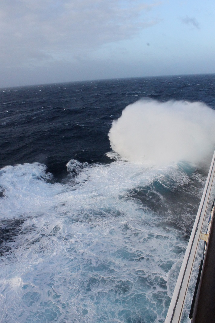
We’ve been through a couple of rough sea days.  Just one picture is quite enough to put you in the picture.


As the captain apologetically said yesterday, “After all, this is the North Atlantic and it is December.”  I’m just grateful that it didn’t get bad enough for them to start stringing hand-ropes across the larger public rooms on board.  This morning, though, things have calmed down a lot and I’m sitting post-breakfast on my balcony, watching the sun light up some clouds, and enjoying the fresh sea breeze.

So I thought I would do a top ten list of things I’ve learned or re-learned in the last 48 hours.

THE TOP 10 REASONS YOU KNOW YOU’RE SAILING IN ROUGH WEATHER

[10]      The outdoor decks are all closed off, including the all-important walking and jogging track.

[9]        The spray is flying past your eighth-deck balcony and coating your sliding glass door.

[8]        The clouds and horizon are doing the shimmy and the waves are doing the twist.

[7]        You curse the clouds, the horizon, and the waves for not getting their act together.

[6]        The dining room suddenly becomes much more popular, since the staff carry everything.

[5]        The pool is drained right to the bottom.  Three-quarters of the drainage is by sloshing.

[4]        The ship’s store is cleaned out of Gravol and pressure bands.

[3]        People stop arguing about whether Gravol works better than pressure bands, or vice versa.

[2]        You get up at 3:00 in the morning to figure out which closet/drawer is banging open and shut.


AND THE NUMBER ONE REASON YOU KNOW YOU’RE SAILING IN ROUGH WEATHER…


[1]        The only people walking in a straight line are the drunks.


But now for the good news.  Yesterday, at the cocktail party for returning guests of Princess, I won the door prize draw: a bottle of sparkling California wine.  Guess what got shared around the table at dinner afterwards!

Last night, with the ship still heaving and lurching unpredictably, the staff captain wanted to cancel the production show in the cabaret.  The singers and dancers were adamant that the show must go on.  They took out a few of the wilder lifts, throws, and spins, but otherwise we got the show in its entirety.  And for the whole of that 45 minute performance, I was completely unaware of any motions the ship was making.  Now, that’s a really impressive example of professional dedication!

********************


A FOOTNOTE:  December 16, 2015

I just wanted to add a couple more quick observations and a couple of even better pictures.  This is our last sea day before Bermuda, and although the waves have been worse on other days this is definitely the windiest day yet.  But, like yesterday, it's sunny and 22 degrees Celsius so pretty nice on the sheltered deck around the pool.  The top deck with the walking/jogging track is closed because of wind speeds (gusts over 80 km/hour).

Another spectacular performance from the singers and dancers last night, again flinging themselves into their routines at full throttle and figuratively thumbing their noses at their pitching and heaving stage.  I got a chuckle this morning as I watched several of them picking their way over the deck by the pool as gingerly as any of their much more senior audiences!

This morning the bow of the ship was flinging some of the biggest clouds of spray yet as we piled into the waves, and I caught a couple of them from my eighth-deck balcony.  Hard for me to estimate the height of the waves from that upper level but I would guess that the swells are running average 12-15 feet with the bigger ones getting up to 20 feet.  


I've also discovered that the ocean is a communist dictatorship.  How else to explain the behaviour demonstrated in this picture?


No matter how much the pool tries to keep all the water on Deck 9 to itself, the ocean brutally and heartlessly causes the ship to heave and pitch, forcing the pool to share of its wealth with the water-deprived deck all around.  If that isn't "communism" at its best, I'd like to know what is!

Friday, December 11, 2015

Holiday in Transition # 11: Have Some Madeira, M'Dear!

As soon as we left Gibraltar the other night, there was no question that we were now out of that placid millpond, the Mediterranean Sea, and on the open Atlantic Ocean.  While I was eating dinner we reached the open water, and the ship immediately took on a long slow pitch over the waves.  Every ten waves or so there came a bigger one which was enough to cause the dining room curtains to sway slightly.  And the water’s been maintaining that rhythm ever since.  Fortunately, it doesn’t bother me, and I slept well for the last two nights.

Our next port of call was the Portuguese island of Madeira, north of Spain’s Canary Islands, southwest of the Straits of Gibraltar, and several hundred kilometres offshore from western Morocco.

It’s a long-extinct volcanic island which has experienced a good deal of erosion, but still sticks up a long way above the ocean.  It’s been a favourite holiday and winter getaway for people from the United Kingdom in particular for many decades.  Even today, tourism is the # 1 industry in Madeira with the famous sweet wines which share the island’s name coming second, and bananas in third place.

The island has a population of over 200,000 people and in such a small land area this inevitably means building up, both in storeys and along hillsides.  Travelling around Madeira therefore involves a great deal of steep hill climbing – and, when not climbing a hill, the road is going through it in one of the numerous tunnels.  It’s a beautiful place, and the air is full of lovely scents from the trees and flowers, once you get clear of the busy capital city of Funchal – whose name, by the way, means “A Plantation of Fennel”.

Once again, here is a place I really want to return to so I can explore more of it, and get beyond the massive urbanized area that flourishes all around Funchal harbour.  The tour I had booked didn’t manage that at all, although it was certainly informative and entertaining.

From the ship we drove along the waterfront to the cable car station where we proceeded to ride up the mountain behind the city.  It was a relaxing 15-minute ride, much longer than the one in Gibraltar, and with seats for everyone (in Gibraltar, they used shoehorn tactics).  Unfortunately, I got a seat facing uphill and with that and the tinted glass couldn’t get any pictures.  However, when we got out at the top, we had this view back down towards the harbour.


In the midst of all the modern construction, the old village of Monte has been carefully preserved as a tourist attraction.  The village square with its overarching trees is just as restful as it looks.


Where most of the people in our tour set off uphill to visit the old church, I went the other way, dropping down a steep path into a valley below the square, which had a lovely little botanical garden.  It was a pleasant surprise that so many flowers were still in bloom in December.


Anyone who’s been to Madeira certainly knows what comes next – the infamous toboggan ride.  It’s a huge operation now, with dozens of wicker-basket toboggans and dozens more traditionally garbed men to pull and ride and steer them.  It’s a very steep 2-kilometre high-speed ride down the paved roads with all their corners and twists and turns.  The crew, if I may so call them, ride on the back and steer the contraption with the aid of two ropes and their traditional goat-skin-soled shoes.  I’m sure the rest of them were just like ours, a pair of comedians who kept pretending that they were going to let the toboggan turn around and slide backwards, or drop a runner into a rain gutter, or slam our elbows into a stone wall.  Of course, they had it completely under control the whole time and it was great fun! 


(note the flat patio apparently tilting up and away at the left side of the picture!)

Our sledge actually threw part of its runner on the way down and they had to add some kind of emergency filler to get us to the end.  The fact that they had the repair kit right in the basket with us suggests that this happens fairly often.  And then at the bottom we saw the truck loaded up with toboggans to be taken back up to Monte, while the crews all stood around waiting (presumably) for vans or a bus for the same purpose.

After that we drove to another viewpoint with this great panorama of the harbour and city.  I didn’t pay much attention other than to think that the third cruise ship, now arrived, looked vaguely familiar.  But later in the day we’ll get back to that subject.


There were also some more lovely flowers blooming around the lookout park, including these spectacular bird-of-paradise flowers, a particular favourite of mine.


From the lookout, we continued down into the city, and then walked along the pedestrian shopping street to reach the premises of the Blandy family firm of wine merchants.  There we had a tasting session of genuine Madeira wines.  As many of you will know, these are very sweet and fortified wines, usually served as an aperitif (if dry) or with dessert (sweet), and running typically to about 19% alcohol, which isn’t far short of the content of an Irish cream or many other liqueurs.  Usually I avoid this sort of thing, being diabetic, but the tastings weren’t large.  We all got a sweet one to start, and then could get up to two more of any kind.  I went from the sweet to the dry, which was still pretty sweet stuff.  This helps to explain why I sheer away from any restaurant dishes made with Madeira sauces!

With that we returned to the ship, and it was such a sunny day that I finally made it into the pool for the first time on this trip.  It’s also warmer.  As we’ve gone farther south, we’re getting closer to the tropics and daytime highs in the low 20s Celsius (i.e. low 70s Fahrenheit) are now the rule, at least for a while.

Oh, yes, that other cruise ship.  Just before we sailed away at 4:45pm, the captain announced that the Phoenix-Reisen’s Artania was the former Princess Cruises’ Royal Princess, a ship in which I had sailed way back in 2000, to Iceland, Norway, and Spitsbergen.  She was a lovely vessel, the first cruise ship in the world built with all outside cabins, and one of the last built with a traditional teak promenade deck running right around the entire perimeter of the ship at Deck 5.  I walked a great deal on that deck during our sea days, and remember that it only took a little over 4 complete laps to go one mile.  She was a wonderful sea boat too, and handled splendidly the few rough days we had on that trip.


And Madeira also had one last treat for us, just as we sailed clear of the harbour.  Shortly after we dropped the harbour pilot off, we picked up another kind of escort.


Yes, Madeira is definitely a place where I’d like to spend more time.  The winter weather is right smack in my comfort zone, the people are very friendly, restaurants all look pleasantly informal, and there’s so much more of the island waiting for me to explore it.

Now, for the next five days, we are “at sea” on the long run across to Bermuda.  Items of concern: daily walks on the track, swimming in the pool (weather permitting), meals, entertainment, and chatting with shipboard friends.  Really nothing much to post about, although I might do a short one about the “sea day” experience before we arrive at out next port of call.

Wednesday, December 9, 2015

Holiday in Transition # 10: World-Famous Boulder

It stands near the southern tip of the Iberian Peninsula like a gigantic exclamation mark – a symbol of British imperial power or of Spanish humiliation, depending on whose viewpoint you take.  But the stark silhouette of the Rock of Gibraltar looms larger still through centuries of history, a fortress whose strength has certainly determined the fate of nations located nowhere near it.

If you are going to visit Gibraltar for the first time, I would recommend a prior crash course in the history of the region and in the history of warfare over the last two to three centuries.  And that is only partly a joke, because the story of Gibraltar the place is the story of Gibraltar the fortress and naval base.  The two are utterly and totally intertwined.

In this respect I was lucky because my historic background prepared me to get a good deal out of the visit – and I was lucky in another way, because my tour guide was a true specialist in Gibraltarian history.

The first thing he pointed out to us was that the famous Prudential Insurance slogan – “Solid as the Rock of Gibraltar” – is sadly founded on an untruth.  The Rock may look solid but, like Ontario’s Niagara Escarpment, it’s made of porous limestone.  The Rock is riddled equally with natural caves and man-made tunnels.  Large portions of the Rock are now in fact hollow!

For this post, a map will certainly be helpful. 

Gibraltar’s location, as much as its height, makes it equally the key to the east-west route through the Straits of Gibraltar, from Atlantic to Mediterranean, and the north-south route from Spain to Morocco.  The Rock was ceded to England by Spain in the Treaty of Utrecht in 1713, and has remained a British possession ever since.  

As a key stopover point en route to the colonies in Africa, India and East Asia, Gibraltar came in for a good deal of attention during both the Napoleonic Wars in the 19th Century and the two great World Wars in the 20th Century.  The combination of Gibraltar and the Spanish city of Algeciras on the west side of the bay has produced what is unquestionably the busiest port we've visited on this cruise.  Gibraltar also served as a key bastion, along with Malta and Cyprus farther east, in protecting the Suez Canal which was the most critical lifeline of imperial trade and defence for the British Empire.

But Gibraltar does have a weakness.  The Rock has only the most limited resources, and depends heavily on links to the outside world for vital supplies – and the only land link is through Spain.  However, Spain has never given up hope of getting Gibraltar back, and there have been times when the border has been closed or at least heavily jammed up with bureaucratic red tape.  Not only that, but the massive Rock takes up so much of the tiny territory that the only possible location for an airport is on that flat strip of land linking the Rock to the Spanish mainland – and the airport sits right beside the border fence.  Indeed, out of sheer necessity, the airport’s runway stretches across the entire width of the peninsula and into the ocean and therefore has to be crossed by the one and only road out of Gibraltar.

On the other hand, Gibraltar does have its own secret weapon – the stubbornly determined Gibraltarian people.  Twice now in referendums they have demonstrated their overwhelming (over 99%) determination to remain as a British territory. 

All in all I was completely engaged and fascinated by the stories told by our guide and the way in which land, water, and people all interweave in those stories.  Among the fascinating spots we visited was the Gibraltar Museum in which the rooms of a genuine preserved Moorish bath rub shoulders with artifacts from the long centuries of warfare in which Gibraltar has changed hands so many times.

So, herewith, a photo portfolio of the unique territory of Gibraltar.  First, a panorama of the Rock from the vantage point of a cruise ship in the harbour.


Europa Point, the southernmost tip of Gibraltar, facing directly towards Morocco across the Straits.


A panorama of the town and harbour from the summit of the rock, at the top of the cable car route.


A panorama of the airport, with the broad main road crossing the runway and the boundary fence extending into the ocean at either side.  The far edge of the modern terminal building sits right on the border.  Beyond lies the Spanish town of La Linea (“The Line”).


The most famous inhabitants of the Rock, its wild monkeys (despite the common name of “Barbary Apes” they are in fact not apes) at the summit station of the cable car.


The interior of the Great Siege Tunnels. These were excavated during the last Spanish attempt to reclaim Gibraltar by force, in the early 1780s.  The tunnels gave access to numerous spots on the north face of the Rock, from which heavy cannon fire could be trained directly down upon the so-called “Neutral Ground” where the airport and La Linea now stand.


After today’s visit, Gibraltar joins the list of places that I want to visit again in more depth.  The next trip to Europe is shaping up to be a very expensive one!