My next expedition (I'm leaving home tomorrow) is a short one -- just a flight out to Seattle, a 7-night cruise to Alaska and back, and flight home.
Alaska is by a far stretch the largest of the USA's 50 states by land area. Few people realize just how much area Alaska sprawls over, until they see a map like this that shows the entire state in one continuous area (with no reduced-scale inserts).

The distance from extreme east (Hyder) to extreme west (Attu Island) is 2261 miles, considerably greater than the straight line distance from Toronto to Vancouver. In one of those funny paradoxes that arise with place names, the very remote archipelago which includes Attu is officially known as the Near Islands. What are they near to? Russia. The next island in the chain, just off the edge of the map, is Russian territory.
There are climate extremes too. Ketchikan in the far southeast has a climate very similar to its Canadian near neighbour in Prince Rupert, and total precipitation averages out to 150 inches a year. On the other hand, the Interior region around Fairbanks (straddling the Arctic Circle) is very dry, and gets some of the most extreme temperatures, with summer highs over 35C and winter lows below -50C both possible. The first time I went to Alaska, in 1995, Fairbanks actually recorded -- while I was there -- a hotter temperature than anywhere in Canada!
There are climate extremes too. Ketchikan in the far southeast has a climate very similar to its Canadian near neighbour in Prince Rupert, and total precipitation averages out to 150 inches a year. On the other hand, the Interior region around Fairbanks (straddling the Arctic Circle) is very dry, and gets some of the most extreme temperatures, with summer highs over 35C and winter lows below -50C both possible. The first time I went to Alaska, in 1995, Fairbanks actually recorded -- while I was there -- a hotter temperature than anywhere in Canada!
The booming Alaskan cruise industry still has a fairly short season of only 4 months or so. At first, virtually all ships sailed from Vancouver, but as the traffic increases and more companies enter the trade, sailings from Seattle and San Francisco have had to be added on -- Vancouver's terminal facilities simply can't handle all the ships.
Because of the short season, there really isn't much of an "off-season" bargain time period. But since the industry is more than amply supplied with cabins now, some bargains may be available on short notice for specific sailing dates.
Because of the short season, there really isn't much of an "off-season" bargain time period. But since the industry is more than amply supplied with cabins now, some bargains may be available on short notice for specific sailing dates.
It usually takes a good 30-36 hours for a ship coming from the south to come onto the bottom right corner of the map above. Most cruises go only as far north as Skagway, at the top end of the Alaskan Panhandle (the long chain of peninsula and islands stretching down along the coast). A few ships carry on westwards to ports south of Anchorage, but most of the cruise business (including the ship I'm taking) lies along the channels of what's known as the Inside Passage to the north. So the next map zooms in on that one region. The green line illustrates the approximate track we'll follow. I can't be sure I've picked exactly the right channels all the way, of course. It's ironic that the easiest way to map the main Alaskan cruise region is to start with a map of British Columbia!
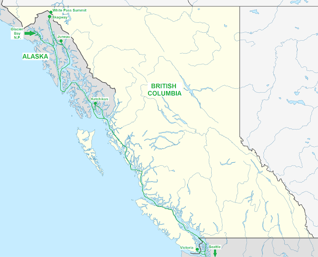
Once you pass the midpoint of Vancouver Island on the way north, virtually every channel is a narrow, steep-sided fjord, hedged in by the coastal mountains. Due to these mountainous conditions, neither Ketchikan nor Juneau has any land connection to the outside world -- and this despite the fact that Juneau is actually located on the mainland. The cost of building such a link, both financial and environmental, has so far proven prohibitive. Frequent flights connect both communities south to Seattle and west to Anchorage, while the state's Marine Highway ferry system links them both north and south, and also serves other smaller communities like Skagway.
Although known, for obvious reasons, as the Inside Passage, this region could as easily and truthfully be called the Golden Coast. Nearly every river shown on this map draining into the Pacific Ocean has spawned a gold rush at some time or other. The last and greatest of all, the Klondike, took place farther north in the depths of the Yukon Territory.
But look right at the top of the map, at the placement of the town of Skagway on the head end of the fjord called Lynn Canal. Those little fingers of water which you see straddling the BC/Yukon border north and east of Skagway are the lakes which form the headwaters of the Yukon River. Historian Pierre Berton pointed out the irony that the river originates barely 50 kilometres from the Pacific Ocean, and then flows well over 3000 kilometres in a huge arc across the Yukon and Alaska just to empty itself into -- you guessed it -- the Pacific Ocean.
Anyway, the White Pass just north of Skagway (together with the nearby Chilkoot Pass and now-abandoned town of Dyea) provided the gateways through the coastal mountains by which most of the stampeders reached the Klondike. But Ketchikan and Juneau had their gold rushes too, earlier on, and so gold rushes form a recurring theme during one of these cruises.
So do glaciers. But it's ironic, to say the least, that the weather along the coast is so un-icy. Glaciers form up in the mountains and descend towards the ocean, but the coastal weather throughout the year is dominated by unfrozen wetness. Be aware, if you take one of these cruises, that the weather is totally unpredictable. You might see glorious sunshine one day, only to be rained in or shrouded in fog for three days after. In this coastal region, the locals have an ironic little nickname for a clear sky -- it's known as a "blue cloud."
Sightseeing is easy in these coastal communities. Whether you pick a ship-marketed tour or just wander on your own, none of these places are huge, and everything is within easy distance. Indeed, many of the tours your cruise offers are sold right on the dock for much lower prices. The only ones that might be hard to get on your own, without pre-arrangement, are any flying tours since virtually all air tours involve very small floatplanes or helicopters. A great way to see the region, if the weather is good, but seats may not be easy to come by if you haven't reserved in advance with somebody.
For history buffs and railway riders, the narrow-gauge White Pass and Yukon Railway (originally opened in 1900) takes you along the gorges the stampeders trekked through, and up to the summit of the White Pass, which marks the border between Canada and the United States in this area. It's an easy trip to take, as the trains start from a track right on the cruise ship dock!
The most awesome spectacle on this trip is Glacier Bay, a National Park west of Juneau and Skagway. Due to the popularity of Alaska cruising, permits for cruise ships to enter Glacier Bay are limited in numbers, and not all cruises can offer this remarkable scenic cruising experience.
I'm off on a cruise to Alaska. Here's a quick outline of the major ports of call on this trip and a synopsis of what you can expect if you head that way too.
ReplyDelete