Sunday, September 12, 2021

Maritime Expedition # 3: In a Sombre Mood

I'm going to be right up front about this: usually, war memorials mean very little to me.  Simple or monumental, they tell me nothing at all about the personalities of the people whose names are engraved there.  They all end up looking much the same -- the same pompous phrases, the same out-of-context quotes from the same poetry, endlessly repeated.  Once you've seen one, you've seen almost all of them.

That's why this memorial, on the harbourfront walkway in Sydney, Nova Scotia, hits me with such power.  You see here people caught in action in a war -- not at parade ground rest, not standing proud, but desperately crying out for help and struggling to stay alive, to survive.  This, the artist seems to tell us, is what "war" is really like, how it actually works.

It's a memorial to a group of warriors whose names are almost invariably forgotten in the endless rhetoric about battlefields and poppies, about navies and air forces.  In fact, these war veterans weren't even entitled to the standard Canadian veterans' pension programs until the 1990s!  

These are the sailors of the "merchant navy," the massive fleets of cargo ships which shuttled back and forth across the North Atlantic during both of the great world wars of the last century, carrying all manner of essential food, weapons, ammunition, medicines, to Europe where the actual fighting took place.

The artist has captured them struggling in the water after their ship has sunk under them, most likely from a torpedo.  The two men at the head of the group reach up to wave, perhaps to call for help, but knowing full well that the convoy they were sailing in cannot -- dare not -- stop to try to rescue them.  They are on their own now.

The lucky ones might get rescued in a few days, thanks to a chance encounter with a westbound warship.  Or they might get picked up by a German warship and interned in Germany.  If the man in the water doesn't get hauled out quickly, he has no chance -- the North Atlantic Ocean is unforgivingly cold at all seasons of the year.

Since the first time I saw this memorial, some explanatory plaques have been added on the pedestal.  These tell us that Sydney was a convoy assembly point for the older and smaller ships, the ones that couldn't keep up with the big convoys of fast, modern ships assembled in Halifax Harbour.  For this reason, the Sydney convoys had an appalling safety record.  Ships were far more likely to be torpedoed on a convoy sailing out of Sydney because they moved so slowly -- since the rule in convoys was always "every ship as fast as the slowest."

I read all of that material, and then looked again at the memorial.  And kept looking again for at least five more minutes without moving away.  For once, I have no more words.


Saturday, September 11, 2021

Maritime Expedition # 2: A Day Living in History

After my short visit to Halifax, I am now back in Cape Breton Island -- the easternmost part of Nova Scotia.  Apart from an all-too-brief stop on a cruise in October of 2015, I have not been down here since June of 2011.  I was pleasantly surprised at how good my memory was for the details of a road that I haven't driven in over a decade.

I was not so pleasantly surprised by the weather.  The dull and dreary conditions of my second day in Halifax prevailed during the 5-hour drive up to Sydney.  The first half of the trip was all cloudy or foggy with periodic spells of rain, while the second half was just cloudy or foggy with occasional little spats of drizzle -- the kind I always call "Scotch mist."

It's too bad because there is some amazing scenery along that highway.  I'll have to worry about capturing it on the way back.  Suffice it to say that Nova Scotia is very much a northern portion of the Appalachian Mountains, and Cape Breton looks the part more than any other part of the province.

At least I made it into Sydney in time to take a refreshing dip in the hotel pool and to get a decent pan-friend haddock dinner at a local pub.  And to find that said pub (a branch of one I've visited in Halifax) was also using the 11011 sign-in system.  Made me feel right at home!

Waking up the following morning brought me this lovely sky and panorama of Sydney harbour outside my windows at the Holiday Inn.  Hint: I booked a King Waterview room, a bit pricier than other rooms, but I got a larger than average corner room with three big windows and plenty of natural light.  Nice!

That drive from Halifax to Sydney:  I allow five hours, which includes time for a lunch and washroom break.  Antigonish, the home of St. Francis Xavier University, is the perfect location for that stop, at almost exactly the halfway point by distance.

Leaving Halifax, you get on the freeway 102 heading north to Truro.  Truro itself is not full of serious attractions for the visitor, but it's hard to avoid because this town really is the crossroads of Nova Scotia in no uncertain terms.  Right on the west edge of town, Highway 102 meets Highway 104.  If you take 104 west, you're on your way to Amherst, the bridge to PEI, Moncton -- and all points west.  Highway 104 east leads to New Glasgow, the ferry to PEI, Antigonish, Cape Breton Island -- and the ferry to Newfoundland.

Highway 102/104 is a 4-lane freeway most of the way to Antigonish, and the final section of 4-lane road is well under construction now.  That huge project includes a totally new road alignment bypassing the narrow, twisting gorge at Marshy Hope, where there simply is no room for road widening.  The nonstop drive to Antigonish took me about 2 hours 10 minutes.

Continuing east after my lunch stop, I soon found myself on a 2-lane highway, although still accessed by interchanges only.  This kind of hybrid freeway works well with the lower traffic volumes in less populated areas of Nova Scotia, and the road is well-provided with passing lane areas on the bigger hills.  Before long, I drove down the long hill to Auld Cove and then out onto the Canso Causeway, the year-round road and rail fixed link across the Strait of Canso to Cape Breton Island.

Strait Superport photo

Word to the Wise:  It's very important to decide on your next move before you drive out onto the causeway, because you are going to have to make a fast choice between three roads, and the junction at the island end of the crossing looks like it was designed by an engineer on a serious drunk night.  Here's a map of it:

 Source:  Google Maps

The challenge is that this spaghetti junction comes flying at you so quickly.  Get over into the the left lane ASAP and take the first left exit around the circle if you want to go up Highway 19 to Inverness on the west side of the island.  Just beyond there, it's the second left exit to go up Highway 105 for Baddeck, the Cabot Trail, and the ferry to Newfoundland.  Stay on the right for Highway 104 to Port Hawkesbury, St. Peter's, Sydney, and Louisbourg.  There are plenty of big overhead signs but good luck trying to read them all as you roll by.  Even though I've driven through here half a dozen times before, I always study the map first to refresh my memory of how the damned thing works.

Of course, you can still get to Sydney by taking Highway 105, but it takes (on Google Maps) about 15 minutes longer.  I did it anyway, thinking I would come back down 104 on the return trip.  Fifteen minutes didn't seem like a big deal.

Ha ha.  There's a lot of truck traffic heading for the Newfoundland ferry and I got stuck in a parade of thirty or more cars behind a real dandy -- a super-size-me flatbed hauling a super-size-me steel tank.  The driver was making about 75-80 on a road with a 100 speed limit, and there are no passing lanes for most of the trip up Cape Breton Island.  Finally, we got to the first passing lane, at Baddeck, and half of us got past the monster.  

Twenty minutes later, at Kelly's Mountain, we hit another one.  Kelly's Mountain is a long climb up, with spectacular views on both sides at the top, and a long hill back down.  The downhill side has a 40 km/h hairpin bend halfway down, and trucks have to go down the hill in low gear.  And there he was: another super-size-me flatbed, crawling down that long hill with a huge hydro transformer sitting on the flatbed.  Down to the bottom, up and across the Seal Island Bridge, and finally got around this # 2 monster at the next passing lane.  Before too much longer, though, I arrived at the outskirts of North Sydney (the ferry port), and picked up the last freeway of the day, Highway 125 around the head of Sydney Harbour to the city of Sydney proper.  Those big slow trucks only cost me about 25-30 minutes extra driving time.  Sigh.

This morning was a perfect day to visit a truly unique historic site, the Fortress of Louisbourg, located about half an hour's drive southeast of Sydney on the shores of the wide-open Atlantic.  Much more than just another fort, Louisbourg was an entire fortified town, all surrounded by massive walls, moats, gun emplacements, and housing a thriving population of French soldiers, tradespeople, craftspeople, merchants, shipowners, shop- and tavern-keepers -- and the list goes on.

The fortifications around Louisbourg looked impressive but the location itself was the Achilles' heel of this massive structure.  Its position on the shore of the ice-free harbour made it an ideal base for shipping, but there was no high ground to allow for true strategic dominance -- as you can see in this picture taken from the lighthouse across the harbour.

Louisbourg was captured by the British in 1745, handed back in the peace treaty negotiations of 1748, and then captured again and levelled to the ground in 1758-1768.  After that period, Britain abandoned the site, concentrating its naval and military might in the strategically far superior harbour at Halifax.

The historic site of today was reconstructed in the 1960s and 1970s, providing employment in the years of work to many of the unemployed miners as the once-thriving Cape Breton coal mines closed down.  The restoration was guided by intensive archival research, the original stones which could be retrieved on the site, and even the remaining foundations of buildings.  Indeed, a couple of the excavated foundations of houses which have not been rebuilt remain visible.

What you see today is a re-creation of the northwestern quadrant of the original town and fortifications as it was in 1744, just before the first siege.  Here's a copy of the map you get from Parks Canada.  You enter through the Dauphin Gate at the bottom of the map.


Throughout the tourist season, Louisbourg opens daily, functioning as a living history museum with large numbers of costumed interpreters guiding you through the lives and activities of the different groups within the population.  It remains the single biggest historic reconstruction project in North American history.  I am always impressed by the good humour and salty realism which the interpreters bring to their work of enlivening the visitor's day!

Enough talking from me, let's take a wander through the streets of this colonial town to see the diverse styles of construction and design that are represented.


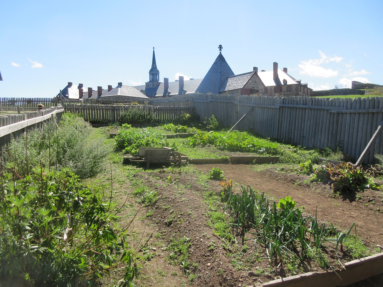
In this challenging environment, the raising of garden vegetables during the relatively short growing season was an essential part of life.  Gardens of vegetables, and gardens of medicinal herbs, are an integral part of the Louisbourg experience.  So are the animals and fowl which the townsfolk kept.


The large towered building which keeps cropping up in the background is the King's Bastion, the largest single structure in the historic site.  It features a 3-story "palace" integrated into the walls of a huge angular bastion, meant to defend the citadel from attack from the landward side.  I have been inside this striking building before, and gave it a miss this time.  I preferred to focus on parts of the town which I had not formerly seen.


One of those new attractions was an interpretive centre inside one of the houses, dedicated to the lives of the Mi'kmaq, the indigenous people who inhabited their homeland of Unamaki (Cape Breton) when the French arrived.  The logs and journals of the French soldiers and people amply testify to the critical role which the Mi'kmaq played in teaching the incomers how to survive and thrive in this harsh and unforgiving environment.  The interpreters in this house were Mi'kmaq who helped visitors to learn and understand better their uniquely nature-based lifestyle and society.

* * * * * * * * * *

A few practical notes: the best time to visit Louisbourg is during the high season, from mid-June to mid-September, as this is when the largest number of costumed interpreters are on the site.

Wear very good sturdy walking shoes.  The walkways in the site are all gravelled, but the gravel is piled fairly loosely.  This kind of walking can be strenuous for those with mobility issues.  Not to worry, it is possible to get a motorized tour on an electric golf cart if necessary.

As with all National Parks and Historic Sites, admission to Louisbourg is already covered if you own a Parks Canada Discovery Pass.  If you're wondering if the pass is worth the cost, I found that just the one-day admission here was equal to 25% of the entire cost of the pass -- so I bought the pass.  After all, I have three or four more parks to visit on this trip alone!

To reach Louisbourg, just follow Highway 22 southeast from Sydney.  Stay on the road through the modern village of Louisbourg.  Just as you leave the village, look for the entrance on the right.  Drive up and park in one of the lots closest to the visitor's centre.  Here you can buy admission, and get a wristband showing your paid-up status.  Take some time to examine the exhibits on the history of Louisbourg before you get on the free shuttle bus to the town gates.  Give yourself plenty of time (as in several hours, minimum).  And not to worry, there are multiple public washrooms and food outlets in the town.


Friday, September 10, 2021

Maritime Expedition # 1: Sleeping In and Eating Out

Okay, the cat is officially out of the bag.  My first big trip of 2021 is a visit to the Maritime provinces of Canada -- those being Nova Scotia, New Brunswick, and Prince Edward Island.

It's less than 2 months since VIA Rail restored service on the Ocean from Montreal to Halifax, my favourite of all their intercity routes.   But for now, it's the same kind of very limited service as the Canadian from Toronto to Vancouver: one trip a week, passengers expected to remain in their rooms, and severely restricted menu of easily reheated foods.  

That made it easy for me to decide in favour of flying to the east coast, and the obvious destination is once again Halifax, the hub city of the Atlantic region, with numerous nonstop daily flights from Toronto, Ottawa, and Montreal.

For most of the pandemic period, Nova Scotia and the other Atlantic provinces were firmly locked down against any not-absolutely-essential travel, but they began loosening their restrictions a bit during the late spring and early summer.  I had to fill in online forms for two travel permits, one for Nova Scotia and one for Prince Edward Island, and those two processes both included uploading a digital image of my vaccine certificate.  One permit was approved instantly, the other in a space of a few hours.  On arrival, I just had to show the approval email on my phone to leave the airport.  Quarantine would be required only if a person is not vaccinated or has received only the first of two doses.

So into Halifax I flew, rented a car, and set up shop for the first three days in the Westin Nova Scotian, the grand dame of all Halifax's hotels.  It was originally a Canadian National Railways hotel, and still has the direct corridor link with the adjacent railway station used by VIA Rail.  The Nova Scotian may not quite equal the utter elegance of such more famous railway hotels as the Chateau Frontenac or the Royal York, but it has a more restrained Georgian classic air (with modern touches here and there) which suits it, and the city, perfectly.  


As the above picture plainly shows, the hotel has 2 main parts -- the original building, completed in 1930 in a Georgian style, and the newer and taller north wing (1959).  The hotel, the station, and the park across the street were conceived as a single unified project.  Here's a 1931 archival photo which shows how the complex looked, as originally built.  The ocean liner posing at the terminal behind the hotel is the RMS Olympic, sister of the ill-fated RMS Titanic.

By Richard McCully Aerial Photograph Collection - Nova Scotia Archives and Records Management, Public Domain, https://commons.wikimedia.org/w/index.php?curid=41238983

The statue of Edward, Lord Cornwallis in the Cornwallis Park across the street has recently been removed, and the park is now rededicated as the Peace and Friendship Park.

As to why I picked the Westin, here are my two main points: 

[1] It pays to check room rates.  For whatever reason or reasons, the Westin was just about the cheapest thing going among downtown Halifax hotels this week.  Normally, it's at or near the top of the price list.

[2] As a Westin hotel, and therefore part of the Marriott hotel family (which I patronize frequently), the Nova Scotian will give me a nice room upgrade if there's space available.  

So on this occasion, I reserved a run-of-house queen bed room (probably in the less-desirable 1959 wing), and here's what I got:


Not to mention the view from the private rooftop terrace with table and chairs outside the room:
 

This "junior suite: is on the top floor of the original wing, facing the park, right in between the pair of towers which you can see in the archive photo above.  I think the Royal Suite is right next door.

The Moral: 

Strong loyalty to one hotel chain pays off no less impressively than strong loyalty to one airline.

I had two full days in Halifax before carrying on to other parts.  The first was gloriously sunny and warm; the second was foggy, drizzly, and dreary -- in a word, blah.  In another word, Scottish.  It's no wonder the earliest refugees from Scotland felt so much at home when they landed here.  Obviously, the following pictures were all taken on Day 1, on a long walk along Halifax's unique and fun-loving Harbourfront Walkway.

This promenade stretches for about 1.5 kilometres (just under a mile), and takes in a huge variety of sights -- and sounds! -- in that distance.  Some parts are paved, bricked, or gravelled paths on dry land, but much of the way is built of close-fitted squared timbers, often located out over the water's edge.  And that last detail goes for some of the attractions along the way too, whether on newly-constructed walkways or atop old harbour piers.

Rather than try to take it in order, I decided to give a thematic overview.  The first and most intriguing thing is Halifax's cute, quirky approach to the omnipresent question of maintaining social distance.  Here are three good examples.


"Quirky" goes farther than signs on the harbourfront.  There's this delightful kids' playground right behind the Maritime Museum, complete with a big Yellow Submarine.


Nearby is "The Wave."  You can tell it's after Labour Day and school is back in.  On weekends and in the summer, this thing is covered with kids!


Public art along the harbour gets quirky too.  Consider these three lamp posts.  The one on the ground represents a fallen Saturday night drunk.  The drunk's friend is bending over with concern.  The third lamp post is bent over towards the edge of the pier, and since it's plainly been a rough Saturday night, it shouldn't be hard to guess what that one's doing -- or just about to do.


A nearby area is given over to this collection of small, brightly coloured kiosks.  They can be adapted for shops, food counters, ticket desks, you name it.  Seems that every time I go to Halifax, they've been moved to a different area of the walkway.


Then there are the numerous monuments and memorials.  I always think of Halifax as the "City of the Sea" (not just the "City on the Sea") because Halifax does so much more than just sit on the edge of the ocean.  The entire history of Halifax for the last 350 years, and all the most significant events in that history, are all tied into the life of the ocean in one way or another.  It's no surprise, then, that stories relating to the ocean, to ships, to sailors, and to ocean travel lie behind all these memorials and others besides.  

The Harbourfront Walkway begins right behind the Westin Hotel.  And right at the beginning stands this dapper, rather cocky statue of Samuel Cunard.  It's amusing to think that the Cunard Line of cruise ships is identified so closely with the classic elegance of British sea travel -- yet Cunard, the line's founder, was a Haligonian (a resident of Halifax, for those not familiar with the unique term).  
 

Samuel Cunard was the first person to operate a line of steamships carrying mail across the Atlantic Ocean -- and, for that reason, the ships of his company were known for a century and a half by the prefix RMS (Royal Mail Ship) instead of the more conventional SS (Steamship).  On the base of his monument, an explanatory plaque includes a silhouette picture of RMS Britannia, the first ship of the Cunard Line to complete a mail voyage across the Atlantic.


A short distance away stands this intriguing pair of sculptural installations.  The one in front of the benches is called The Volunteers, and pays tribute to all the work done by women and children in Canada during the world wars of the 20th century to support the war effort.  Behind the benches, the Immigrant shows a symbolic immigrant figure about to take the big step off the bow of a ship and into a new homeland (fittingly not depicted-- a leap of faith into the unknown).  I sometimes wonder why this piece, as moving as it is, wasn't positioned a few hundred metres farther south, in front of the Canadian Immigration Museum at Pier 21.


Again, a short further walk brings you to this memorial to the ships lost at sea in World War Two.  One of them, the corvette HMCS Trentonian, was the vessel on which my uncle lost his life when the ship was torpedoed a few short months before the war's end.


Near the midpoint of the walkway, you would have to detour off the main route into a shady courtyard between two modern buildings.  There, you will see another memorial to sailors who went down to the sea in ships during wartime and -- in some cases -- never returned.

 
The newest addition, since my last visit 2 years ago, is this memorial to the Grand Dérangement of les acadiens in the mid-1700s.  I hope it will be placed in a more suitable location once the work on the construction site behind it is finished.


The map on the memorial shows how les acadiens were dispatched from Nova Scotia by sea to multiple destinations around the Atlantic rim.  Definitely one of the saddest sea stories connected to this city, a long-time British (and later Canadian) naval stronghold.

On a brighter note, I simply had to take advantage of the beautiful weather for a patio lunch on my favourite patio in Halifax, perhaps my favourite patio in the world.  The sun, the water right there beside you, the view, and what still ranks as one of the finest lobster rolls I've ever had in my life, matched with a delicious spinach salad.  Salty's does it again!


The restaurants of Halifax, at least all the half dozen or so that I visited, have come up with a grand scheme to simplify the sign-in process for Covid tracking.  All you do is text the restaurant name in the format they give you, and your own name, to 11011.  Instantly you get back a confirmation to show to the host.  Since they all use the same number, it's very easy to access again once you've used it.  Smart thinking there!
 
Later that evening, I went for dinner at the Waterfront Warehouse, another long-time favourite which is especially good for oyster lovers.  There, I saw this lovable bit of good humour at the top of the drink menu.
 

On a final note, nothing makes the waterfront a people place quite so much as the various festivals and public events promoted there during good weather in all seasons.  On the particular day I took my walk, there was a fairly big open-water swim in the harbour just winding up, and numerous people in wetsuits still lingering around the finish point to congratulate each finisher loudly.  Nearby, on the pier with the lamp post sculptures, a band was playing to add to the fun.

An even more delightful sight, although I didn't get a picture because it was too dark, happened in a gazebo at another point on the waterfront as I headed back to the hotel after dinner.  This time, it was not live music, just soundtrack, but speakers were pumping out some beguiling cha-cha music and seven or eight couples were dancing happily on the waterfront.  I'll bet my parents would have joined in if they had been there!