After my short visit to Halifax, I am now back in Cape Breton Island -- the easternmost part of Nova Scotia. Apart from an all-too-brief stop on a cruise in October of 2015, I have not been down here since June of 2011. I was pleasantly surprised at how good my memory was for the details of a road that I haven't driven in over a decade.
I was not so pleasantly surprised by the weather. The dull and dreary conditions of my second day in Halifax prevailed during the 5-hour drive up to Sydney. The first half of the trip was all cloudy or foggy with periodic spells of rain, while the second half was just cloudy or foggy with occasional little spats of drizzle -- the kind I always call "Scotch mist."
It's too bad because there is some amazing scenery along that highway. I'll have to worry about capturing it on the way back. Suffice it to say that Nova Scotia is very much a northern portion of the Appalachian Mountains, and Cape Breton looks the part more than any other part of the province.
At least I made it into Sydney in time to take a refreshing dip in the hotel pool and to get a decent pan-friend haddock dinner at a local pub. And to find that said pub (a branch of one I've visited in Halifax) was also using the 11011 sign-in system. Made me feel right at home!
Waking up the following morning brought me this lovely sky and panorama of Sydney harbour outside my windows at the Holiday Inn. Hint: I booked a King Waterview room, a bit pricier than other rooms, but I got a larger than average corner room with three big windows and plenty of natural light. Nice!

That drive from Halifax to Sydney: I allow five hours, which includes time for a lunch and washroom break. Antigonish, the home of St. Francis Xavier University, is the perfect location for that stop, at almost exactly the halfway point by distance.

Leaving Halifax, you get on the freeway 102 heading north to Truro. Truro itself is not full of serious attractions for the visitor, but it's hard to avoid because this town really is the crossroads of Nova Scotia in no uncertain terms. Right on the west edge of town, Highway 102 meets Highway 104. If you take 104 west, you're on your way to Amherst, the bridge to PEI, Moncton -- and all points west. Highway 104 east leads to New Glasgow, the ferry to PEI, Antigonish, Cape Breton Island -- and the ferry to Newfoundland.
Highway 102/104 is a 4-lane freeway most of the way to Antigonish, and the final section of 4-lane road is well under construction now. That huge project includes a totally new road alignment bypassing the narrow, twisting gorge at Marshy Hope, where there simply is no room for road widening. The nonstop drive to Antigonish took me about 2 hours 10 minutes.
Continuing east after my lunch stop, I soon found myself on a 2-lane highway, although still accessed by interchanges only. This kind of hybrid freeway works well with the lower traffic volumes in less populated areas of Nova Scotia, and the road is well-provided with passing lane areas on the bigger hills. Before long, I drove down the long hill to Auld Cove and then out onto the Canso Causeway, the year-round road and rail fixed link across the Strait of Canso to Cape Breton Island.

Word to the Wise: It's very important to decide on your next move before you drive out onto the causeway, because you are going to have to make a fast choice between three roads, and the junction at the island end of the crossing looks like it was designed by an engineer on a serious drunk night. Here's a map of it:

Source: Google Maps
The challenge is that this spaghetti junction comes flying at you so quickly. Get over into the the left lane ASAP and take the first left exit around the circle if you want to go up Highway 19 to Inverness on the west side of the island. Just beyond there, it's the second left exit to go up Highway 105 for Baddeck, the Cabot Trail, and the ferry to Newfoundland. Stay on the right for Highway 104 to Port Hawkesbury, St. Peter's, Sydney, and Louisbourg. There are plenty of big overhead signs but good luck trying to read them all as you roll by. Even though I've driven through here half a dozen times before, I always study the map first to refresh my memory of how the damned thing works.
Of course, you can still get to Sydney by taking Highway 105, but it takes (on Google Maps) about 15 minutes longer. I did it anyway, thinking I would come back down 104 on the return trip. Fifteen minutes didn't seem like a big deal.
Ha ha. There's a lot of truck traffic heading for the Newfoundland ferry and I got stuck in a parade of thirty or more cars behind a real dandy -- a super-size-me flatbed hauling a super-size-me steel tank. The driver was making about 75-80 on a road with a 100 speed limit, and there are no passing lanes for most of the trip up Cape Breton Island. Finally, we got to the first passing lane, at Baddeck, and half of us got past the monster.
Twenty minutes later, at Kelly's Mountain, we hit another one. Kelly's Mountain is a long climb up, with spectacular views on both sides at the top, and a long hill back down. The downhill side has a 40 km/h hairpin bend halfway down, and trucks have to go down the hill in low gear. And there he was: another super-size-me flatbed, crawling down that long hill with a huge hydro transformer sitting on the flatbed. Down to the bottom, up and across the Seal Island Bridge, and finally got around this # 2 monster at the next passing lane. Before too much longer, though, I arrived at the outskirts of North Sydney (the ferry port), and picked up the last freeway of the day, Highway 125 around the head of Sydney Harbour to the city of Sydney proper. Those big slow trucks only cost me about 25-30 minutes extra driving time. Sigh.
This morning was a perfect day to visit a truly unique historic site, the Fortress of Louisbourg, located about half an hour's drive southeast of Sydney on the shores of the wide-open Atlantic. Much more than just another fort, Louisbourg was an entire fortified town, all surrounded by massive walls, moats, gun emplacements, and housing a thriving population of French soldiers, tradespeople, craftspeople, merchants, shipowners, shop- and tavern-keepers -- and the list goes on.
The fortifications around Louisbourg looked impressive but the location itself was the Achilles' heel of this massive structure. Its position on the shore of the ice-free harbour made it an ideal base for shipping, but there was no high ground to allow for true strategic dominance -- as you can see in this picture taken from the lighthouse across the harbour.

Louisbourg was captured by the British in 1745, handed back in the peace treaty negotiations of 1748, and then captured again and levelled to the ground in 1758-1768. After that period, Britain abandoned the site, concentrating its naval and military might in the strategically far superior harbour at Halifax.
The historic site of today was reconstructed in the 1960s and 1970s, providing employment in the years of work to many of the unemployed miners as the once-thriving Cape Breton coal mines closed down. The restoration was guided by intensive archival research, the original stones which could be retrieved on the site, and even the remaining foundations of buildings. Indeed, a couple of the excavated foundations of houses which have not been rebuilt remain visible.

What you see today is a re-creation of the northwestern quadrant of the original town and fortifications as it was in 1744, just before the first siege. Here's a copy of the map you get from Parks Canada. You enter through the Dauphin Gate at the bottom of the map.

Throughout the tourist season, Louisbourg opens daily, functioning as a living history museum with large numbers of costumed interpreters guiding you through the lives and activities of the different groups within the population. It remains the single biggest historic reconstruction project in North American history. I am always impressed by the good humour and salty realism which the interpreters bring to their work of enlivening the visitor's day!
Enough talking from me, let's take a wander through the streets of this colonial town to see the diverse styles of construction and design that are represented.


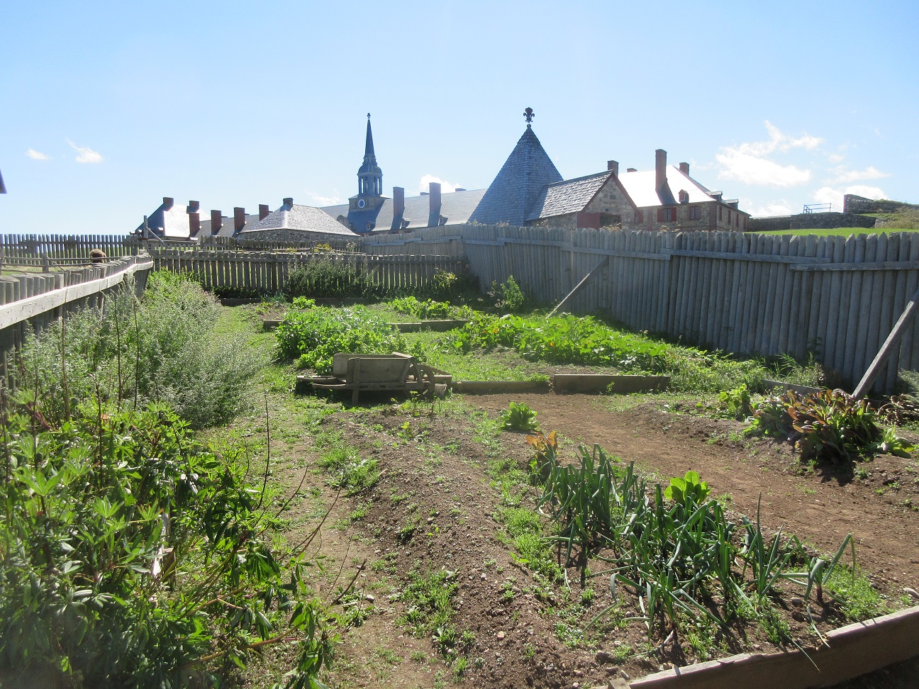
In this challenging environment, the raising of garden vegetables during the relatively short growing season was an essential part of life. Gardens of vegetables, and gardens of medicinal herbs, are an integral part of the Louisbourg experience. So are the animals and fowl which the townsfolk kept.


The large towered building which keeps cropping up in the background is the King's Bastion, the largest single structure in the historic site. It features a 3-story "palace" integrated into the walls of a huge angular bastion, meant to defend the citadel from attack from the landward side. I have been inside this striking building before, and gave it a miss this time. I preferred to focus on parts of the town which I had not formerly seen.
One of those new attractions was an interpretive centre inside one of the houses, dedicated to the lives of the Mi'kmaq, the indigenous people who inhabited their homeland of Unamaki (Cape Breton) when the French arrived. The logs and journals of the French soldiers and people amply testify to the critical role which the Mi'kmaq played in teaching the incomers how to survive and thrive in this harsh and unforgiving environment. The interpreters in this house were Mi'kmaq who helped visitors to learn and understand better their uniquely nature-based lifestyle and society.
* * * * * * * * * *
A few practical notes: the best time to visit Louisbourg is during the high season, from mid-June to mid-September, as this is when the largest number of costumed interpreters are on the site.
Wear very good sturdy walking shoes. The walkways in the site are all gravelled, but the gravel is piled fairly loosely. This kind of walking can be strenuous for those with mobility issues. Not to worry, it is possible to get a motorized tour on an electric golf cart if necessary.
As with all National Parks and Historic Sites, admission to Louisbourg is already covered if you own a Parks Canada Discovery Pass. If you're wondering if the pass is worth the cost, I found that just the one-day admission here was equal to 25% of the entire cost of the pass -- so I bought the pass. After all, I have three or four more parks to visit on this trip alone!
To reach Louisbourg, just follow Highway 22 southeast from Sydney. Stay on the road through the modern village of Louisbourg. Just as you leave the village, look for the entrance on the right. Drive up and park in one of the lots closest to the visitor's centre. Here you can buy admission, and get a wristband showing your paid-up status. Take some time to examine the exhibits on the history of Louisbourg before you get on the free shuttle bus to the town gates. Give yourself plenty of time (as in several hours, minimum). And not to worry, there are multiple public washrooms and food outlets in the town.
No comments:
Post a Comment